The Village of Saugerties’ water supply is already under immense strain.
The reservoir can provide 1.8 million gallons per day. A 2020 report shows a peak of 1.627 million gallons. Any new development projects will increase pressure on the water supply.
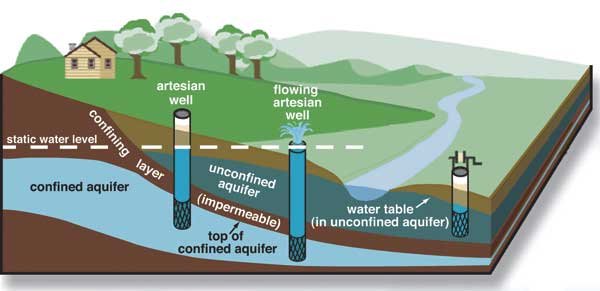
The Winston Farm site is part of an aquifer protection overlay district that protects underground water.
Learn more about aquifers and wells here.
A 2022 hydrology report, commissioned by the Saugerties planning board, states that any development on Winston Farm should take into account the “risk to the valley bottom aquifer, and protection of a high-yield aquifer that might one day serve as the cornerstone for future growth in the Town of Saugerties.”
Aquifer Protection
Key issues: Withdrawal amount, well depth tests, future use of the aquifer by the Village and Town of Saugerties.
Withdrawal amounts: the DGEIS used values that are out of the range commonly used for water consumption (100 gallon per day per resident instead of the more commonly used 200-400 gallons) and less than three(3) residents per household. These estimates lead to an underestimated consumption, and likely a much higher drawdown of the aquifer.
The report concludes that the water capacity for Winston Farm is 270 gpm, but this figure is obtained by adding the 220 gpm from the Winston Farm test well to the 50 gpm of the Montano well, which is not on the property. It is not clear why the applicants feel these are additive.
Over the past 10-15 years the Village and Town Board conducted studies and plans for sustainable development. These involved the use of the same TW-1 well along State Route 212, and resulted in the designation of Aquifer, Gateway and Scenic Protection Overlays. These studies and designations conducted with goals to meet climate change impact cannot be ignored as they will count towards the State’s goal of addressing the challenges.
SPDES Permit and Receiving Waterbody Flow
Pumping water from wells is not the end of the story. Whether it is used for direct consumption by households or other uses, water will end up as wastewater. Developers are brushing the issue by stating that they will obtain a SPDES permit. The receiving waterbody is listed as the Beaverkill.
The Beaverkill is a small, shallow, winding, capricious, beautiful stream flowing through several State regulated wetlands between Route 212 (to the South) and Route 32 (to the North). It overflows its banks during rain events and snowmelts, flooding existing wetlands and damaging mature forest growth. There was little flow during the October-November 2024 drought. DEC info Locator identifies the Beaverkill as a Class 3 stream, and as an “unassessed waterbody.” As residents we can attest to its water quality. The Beaverkill should be re- classified as a Class 2 stream. Currently, there are no water discharge upstream. Turbidity following storm events is visible, but not unexpected due to clay. There is no flow data, no aquatic biological monitoring data, yet the observed aquatic invertebrate population is diverse and abundant, so are the vertebrate animals living along its banks.
Base flow is unlikely to be over 270 gpm. The issuance of a SPDES permit must remain conform to DEC’s TOGS (Section 1.3.3) for dilution mixing. Discharge flow from a wastewater plant cannot be higher than the receiving waterbody flow. We need DEC’s assistance to (a) implement flow monitoring of the Beaverkill, and (b) guide the developers to seek a larger waterbody for discharges of its wastewater.


